
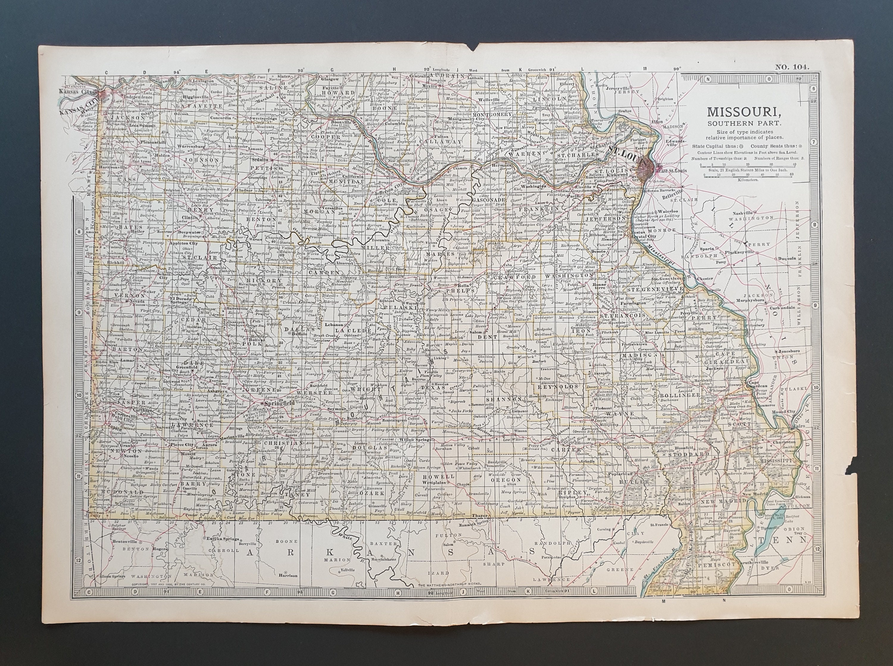
This is an original antique map, not a print or a copy.
Source: The Century Atlas 1902 (Published in the USA)
Lovely detailed map, measuring 12.5 x 17 inches.
In overall good condition, although given it's age there may be some small tears, foxing or stains. Please look at the picture as this is the item you will receive and forms part of the description.
Map will be sent folded along it's pre-existing crease, with a loose cardboard backing with the details written on the reverse, and in a cello bag for protection.
*Please Note* We use Etsy labels for all our postage, which prints any address information we have been given directly without any editing.
Please ensure that this is correct before submitting, as we cannot be held responsible for any incorrect spelling of names or addresses, missing information, incorrect addresses. This is particularly crucial for posting overseas which can also cause delays at customs.
Shipping from United Kingdom
Processing time
1-2 business days
Customs and import taxes
Buyers are responsible for any customs and import taxes that may apply. I'm not responsible for delays due to customs.
Payment Options
Returns & Exchanges
Returns & exchanges accepted within 14 days
Buyers are responsible for return shipping costs. If the item is not returned in its original condition, the buyer is responsible for any loss in value.
I gladly accept returns, exchanges, and cancellations
Request a cancellation within: 4 hours of purchase
The following items can't be returned or exchanged
Because of the nature of these items, unless they arrive damaged or defective, I can't accept returns for:
- Custom or personalized orders
Conditions of return
Buyers are responsible for return shipping costs. If the item is not returned in its original condition, the buyer is responsible for any loss in value.
Questions about your order?
Please contact me if you have any problems with your order.
Privacy policy
This Privacy Policy describes how and when we collect, use, and share information when you purchase an item from us, contact us, or otherwise use our services through Etsy.com or its related sites and services. This also applies to our website which uses Pattern (Etsy) as its platform.
This Privacy Policy does not apply to the practices of third parties that we do not own or control, including Etsy or any third party services you access through Etsy. You can reference the Etsy Privacy Policy to learn more about its privacy practices.
Information Collected
To fulfil your order, you must provide us with certain information (which you authorised Etsy to provide to us), such as your name, email address, postal address, payment information, and the details of the original antique or vintage item that you’re ordering.
Why we need your Information and how we use it.
We rely on a number of legal bases to collect, use, and share your information, including:
As needed to provide our services, such as when we use your information to fulfil your order, to settle disputes, or to provide customer support;
If necessary to comply with a legal obligation or court order or in connection with a legal claim, such as retaining information about your purchases if required by UK tax law; and as necessary for the purpose of our legitimate interests, if those legitimate interests are not overridden by your rights or interests, such as 1) providing and improving our services. We use your information to provide the services you requested and in our legitimate interest to improve our services; and 2) Compliance with the Etsy Seller Policy and Terms of Use. We use your information as necessary to comply with my obligations under the Etsy Seller Policy and Terms of Use.
Information Sharing and Disclosure Information about our customers is important to our business. We share your personal information for very limited reasons and in limited circumstances, as follows:
Etsy. We share information with Etsy as necessary to provide you our services and comply with our obligations under both the Etsy Seller Policy and Etsy Terms of Use.
Service Providers. We engage certain trusted third parties to perform functions and provide services to our shop, such as delivery companies. We will share your personal information (name and address only) with these third parties, but only to the extent necessary to get your order to you.
Compliance with laws. We may collect, use, retain, and share your information if we have a good faith belief that it is reasonably necessary to: (a) respond to legal process or to government requests; (b) enforce my agreements, terms and policies; (c) prevent, investigate, and address fraud and other illegal activity, security, or technical issues; or (d) protect the rights, property, and safety of our customers, or others.
Data Retention
We retain your personal information only for as long as necessary to provide you with our services and as described in our Privacy Policy. However, we may also be required to retain this information to comply with our legal and regulatory obligations, to resolve disputes, and to enforce our agreements.
We will only contact you in regard to your order, query or dispute. This will be sent through Etsy or our Pattern website. We do not use your information outside of this for any other purpose. At this time we do not have a mailing list, so therefore any external information purporting to have come from us will not be legitimate.